


Tra Vinh Province

2341.2 km2

Mekong River Delta

3

3448

1,012,600 people (2010)
 Geography
 Economy
 Connection
 Infrastructure
 Government
 Social - Culture
| Total Area | 2341.2km2 |
| Agricultural Production Land | 1480 km2 |
| Forestry Land | 67 km2 |
| Specially Used Land | 139 km2 |
| Residential Land | 45 km2 |
|
65 km |
|
| Borders |
East by the Bien Dong Sea, Vinh Longon the west, Soc Trang on the south, north is Ben Tre Province |
|
Climate
Lying in the coastal tropical monsoon region, Tra Vinh has general advantages of abundant radiation, high and stable temperature. However, being a coastal province Tra Vinh suffers strong winds from the east and southeast, high evaporation, and less rain.
|
|
|
Natural Resources
Land resources: According to the General Statistics Office, the total natural area of Tra Vinh until 01-01-2008 is 229,500 ha. In general, 56% and 27% of the soil in Tra Vinh are affected by respective salinity and alum. To improve the land utilization efficiency, the province should implement desalination projects. The South Mang Thit Project is one of the major irrigation works of the Ministry of Agriculture and Rural Development, aiming at salinity control, fresh water holding, drainage, and alum washing for nearly 171,626 ha of cultivation land and 225,628 ha of natural land. Moreover, the projects also provides fresh water for the locals’ utilization in combination with fishery and transport development, and environmental improvement. Water resources: The 2 rivers of Co Chien and Hau are main suppliers of water for the provincial production and living. Besides, there is a network of complicated waterways providing water for paddy fields. The canal density distribubes relatively even, from 4 - 10 m/ha, increasing to the highest in Tieu Can District (45 m/ha) and decreasing to the lowest in disrtricts of Duyen Hai, Tra Cu, and Cau Ngang (18 – 28 m/ha). Mineral resources: The province is formed by young deposition mixed with marine and riverine alluvium sedimentation. Consequently, the minerals comprise only sand for construction, ground filling and a little amount of clay. Forest resources: There are about 24,000 ha. of forest and forestry land along 65 km coastline, including the whole Duyen Hai District, My Long Commune (northern, southern) Cau Ngang District, and Don Chau, Don Xuan Communes of Tra Cu District. |
|
| GDP Growth Rate | 6.68% (2015) |
| Population | 1,012,600 people (2010) |
| Population Density | 442 person/km2 (2015) |
| Population By Sex | 95.9 males per 100 females (2015) |
7.10% (2015) |
|
| Immigration Rate | 2.80% (20150 |
| Labor Force | 22,000 workers (2016) |
| Labor Force At 15 Years Of Age And Above | 57.90% (2015) |
| Unemployment Rate | 3.8% (2016) |
|
Major Industries
Mining, processing, fabrication, manufacturing, and distribution of electricity. |
|
| Annual Average Capital Of Enterprises | 15,925 billion dongs (2014) |
| Net Turnover | 29,559 billion dongs (2014) |
| Profit Before Taxes | 669 billion dongs (2014) |
| Profit Ratio | 2.25% (2014) |
| PCI | 57.55 (2015) - Rank: 41 |
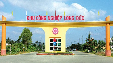
Total Area: 100.6m2
Occupancy Rate: 0%
Address: Long Duc, Tra Vinh, Tra Vinh, Vietnam
|
Transportation
Roads: The province has 2,111.6 km of road, of which the national road accounts for 10.2%, the provincial road: 21.5%, and the district road: 68.3%. Regarding overland traffic, there are three national roads (NR) no. 53, 54, and 60 which have been upgraded to level 3, connecting Tra Vinh with HCMC and other provinces in the Mekong Delta. NR no. 53 and NR no. 54 connect Tra Vinh with Vinh Long Province (56 km) and Can Tho City (95 km). Tra Vinh is about 200 kms from HCMC by the mentioned two national roads. However, the distance will be shortened to 130 km if traveling on NR no. 1A and NR. no 60 which is scheduled to traffic in 2015 and connected with Trung Luong Freeway. Moreover, the Ministry of Transport started in 2009 the project of bridge contruction on the Co Chien River belonging to NR no. 60 to connect two provinces of Tra Vinh and Ben Tre. Once completed, these arterial roads will link Tra Vinh Province with Ben Tre Province, HCMC, and the southeastern provinces together with facilitation of investment, trade, tourism, import and export. Simultaneously, the opening of Cau Quan - Dai Ngai Ferry will link Tra Vinh with Soc Trang Province on NR no.60. Waterways: Tra Vinh is bordered the East Sea to the east and surrounded by the Tien River and the Hau River, thus, waterway transportation is relatively developed. The province has passageways for seagoing ships of 20,000 ton to enter the Hau River (Tra Vinh Canal) ane to reach the East Sea via Dinh An Economic Zone. This is a good condition for developing the Tra Cu port system and Dinh An international transshipment port. The main waterways for commodity shipment comprise of vertical and horizontal axes. The former is river line of Co Chien River – Tra Ngoa Canal and 3/2, the latter, Nguyen Van Pho line – Can Chong River – Ben Cat River which links the Tien River with the Hau River. It takes from 5 – 7 hours by ship from Dinh An estuary to Con Dao Island (Ba Ria - Vung Tau Province) and about 3 hours to Can Tho City. There are 2 ports in Cung Hau estuary and Dinh An estuary. Two rivers of Co Chien and Bassac can accommodate ships of 3,000 tons. Currently the river port Long Duc, closely connected with Long Duc Industrial Park, is capable to accommodate ships and barges of 1,000 tons. The project of Quan Chanh Bo Canal started in 2009 to facilitate entry of seagoing vessels of 20,000 – 40,000 tons on the Hau River to Cai Cui Port, Can Tho City. Thanks to this waterway, Tra Vinh could build an international trans-shipment port of 40,000 ha. The People’s Committee of Tra Vinh Province approved the project of zoning and building Long Toan Port in Duyen Hai Disrtrict, with an area of 170 ha and an investment capital of 1,700 billion VND. It is expected that the port will receive about 1,000 laborers and shorten the waterway tranport from HCMC throught the Hau River to the East Sea. |
|
|
Water Supply
The water plant in Tra Vinh City with a capacity of 18,000m3/day-night is proposed to be increased to 50,000m3/day-night. All townships and residential areas have public water supply stations. The province plans to have another water plant of 18,000m3 capacity contructed in Duyen Hai District. |
|
|
Electric Supply
In 2010, the merchandized electric output is 425.5 million kWh. There is a 60km- 220kV electric transmission line together with a 220kV transformer station of 115MVA. At present, all communes and towns have accessed to national grid and the 4,400-MW Duyen Hai power centre is being built. The first turbine with a capacity of 1,200 MW is expected to be completed and put into operation in early 2015. |
| People's Council | 242, Le Loi Street, Ward 1, Tra Vinh City, Tra Vinh Province. |
| People's Committee | 52A, Le Loi Street, Ward 1, Tra Vinh City, Tra Vinh Province. |
| Relevant Government Departments |
|
| Province | Tra Vinh Province |
| Headquarter of People's Committee | 52A, Le Loi Street, Ward 1, Tra Vinh City, Tra Vinh Province. |
| Official Provincial (or City) Website | www.travinh.gov.vn |


