


Tay Ninh Province

4032.6 km2

Southeast

5

8345

1,112,000 people (2015)
 Geography
 Economy
 Connection
 Infrastructure
 Government
 Social - Culture
| Total Area | 4032.6km2 |
| Agricultural Production Land | 2699 km2 |
| Forestry Land | 722 km2 |
| Specially Used Land | 269 km2 |
| Residential Land | 91 km2 |
| Borders |
East by the province of Binh Duong and Binh Phuoc, South and Southeast Ho Chi Minh City and Long An province, northern and northwestern bordering with 3 provinces of Cambodia: Svay Rieng, Veng and Tbong Khmum. One of the most important advantages of Tay Ninh is port trade economic development basing on exploration of the border gate system. Tay Ninh has 240km of borderline with Cambodia and has 14 pairs of border gates (of which there are two international border gates: Moc Bai and Xa Mat) |
|
Climate
Tay Ninh’s climate is rather moderate and has 2 plain main seasons. The dry season starts from December to April, and the rain season from May to November. The average annual temperature is 27.2oC. The average rainfall is from 1,770 to 2,100 mm. The average annual humidity is about 84.9%. Tay Ninh is affected with 2 kinds of wind: eastern wind (north and northeast directions), monsoon wind (west and south-west directions). |
|
|
Natural Resources
Land resource: There are 5 main kinds of land in Tay Ninh, and total area is 402,817 square hectares, among which:
Water resources: Surface water resource depends mainly on the two big rivers of Sai Gon and Vam Co Dong. The Sai Gon river starts from Loc Ninh (Binh Phuoc), which has total length of 280km. One route running along the border of Tay Ninh and Binh Phuoc, Binh Duong provinces is 135 km in length. One route running through internal Tay Ninh province is 18km in length. The average volume of water is 85 m3 /s. The slop of the riverbed is small (0.7%), so it can cause flood slowly. Underground water source: Tay Ninh has underground water source distributed in areas with the largest flow of water, good quality. In southern districts of this province, there is more underground water source distributed near the surface than the northern areas. In the dry season, volume of the underground water can still be exploited well, ensuring quality for life and production. Mineral resource: Mineral resources of Tay Ninh province are mainly non-metal such as limestone, peat, pebble, gravel, sound, and clay.
Tay Ninh has some mineral water mines, among which mineral water mine in Ninh Dien commune, Chau Thanh district is being exploited by Ninh Dien mineral water factory |
|
| GDP Growth Rate | 11% (2014) |
| Population | 1,112,000 people (2015) |
| Population Density | 276 person/km2 (2015) |
| Population By Sex | 99.0 males per 100 females (2015) |
7.30% (2015) |
|
| Immigration Rate | 1.80% (2015) |
| Labor Force At 15 Years Of Age And Above | 57.10% (2015) |
|
Major Industries
Tay Ninh Province focus on development of farm products processing, especially sugar, wheat flour, rubber industries, intensive labour industries such as garment etc; |
|
| Annual Average Capital Of Enterprises | 76,784 billion dongs (2014) |
| Net Turnover | 114,027 billion dongs (2014) |
| Profit Before Taxes | 1,719 billion dongs (2014) |
| Profit Ratio | 1.49% (2014) |
| PCI | 59.66 (2015) - Rank: 16 |
Total Area: 203.8m2
Occupancy Rate: 0%
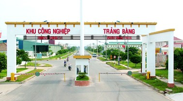
Address: Trang Bang, Tay Ninh
Total Area: 200m2
Occupancy Rate: 0%
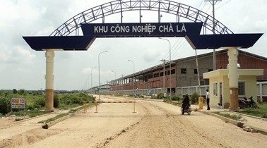
Address: Cha La, Duong Minh Chau, Tay Ninh
Total Area: 2190m2
Occupancy Rate: 0%
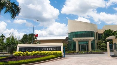
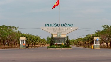
Address: Phuoc Dong, Go Dau, Tay Ninh

Total Area: 1020m2
Occupancy Rate: 0%
Address: An Hoa, Trang Bang, Tay Ninh
|
Transportation
Road: The total road length of the province is 3,112km, of which there are 762km of national highway, provincial road, and the rest is rural road. Asphalted roads and concreted roads make up about 925km (29.27%). Red gravel and sand roads make up about 2, 174km (70%). Macadam roads are about 12km (0.3%). Tay Ninh has Trans – Asia road crossing with the length of 28km. This road connects Ho Chi Minh City to Cambodia through Moc Bai interna tional border gate. Besides, Tay Ninh has the national highway N0 22B, which is the main route running from north to south. These are 2 important, strategic routes to develop defense – security – society – economy for Tay Ninh and the southern key economy region. There are about 99 bridges with the total length of 3,331 m. Water way: The water way network includes 2 main routes: The Sai Gon river route connecting Tay Ninh to Ho Chi Minh City and the Vam Co river route connecting Tay Ninh to Long An. Airway: Tay Ninh can develop an airfield from material bases left from the military airfield in Thai Binh town, Chau Thanh district. An airfield of level of 4-5 and airstrip with 25-30 meters in width and 1000 meters in length can be built to receive aircrafts with 50-70 seats. On the other hand, a field for helicopters to land on can be built on Ba Den mountain for tourism service. |
|
|
Telecommunications
Services of post and telecommunications are more and more diversification. The numbers of posts, capacities of switchboard are more and more increased. Tay Ninh can be connected to many places in the country and other countries of the world. |
|
|
Water Supply
Water supply system’s total capacity in Tay Ninh is about 36,300 cubic meter/ a day. The province is calling upon investment into 2 water works in Trang Bang industrial park and Moc Bai border gate economic zone to supply enough water for the 2 main economic areas. |
|
|
Electric Supply
At present, Tay Ninh electricity is supplied from Thac Mo hydropower station through 100 kV line of Thac Mo – Tay Ninh and is connected to a 210/110 kV station of Hoc Mon through a 110kW line of Hoc Mon-Cu Chi-Trang Bang (Tay Ninh). An electric system is a ring circuit of 110 kW to Tay Ninh, in case there is trouble, electric lines will be connected each other.
|
| People's Committee | 136 Tran Hung Dao Street, Ward 2, Tay Ninh City, Tay Ninh Province. |
| Relevant Government Departments |
|
| Province | Tay Ninh Province |
| Headquarter of People's Committee | 136 Tran Hung Dao Street, Ward 2, Tay Ninh City, Tay Ninh Province. |
| Official Provincial (or City) Website | www.tayninh.gov.vn |


