


Kon Tum Province

9676.5 km2

Central Highland

2

3822

473,300 people (2013)
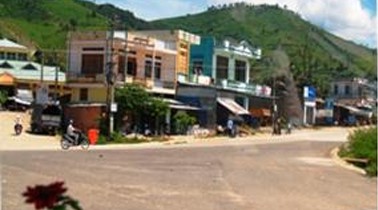
 Geography
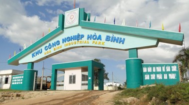
 Economy
 Connection
 Infrastructure
 Government
 Social - Culture
| Total Area | 9676.5km2 |
| Agricultural Production Land | 2154 km2 |
| Forestry Land | 6411 km2 |
| Specially Used Land | 278 km2 |
| Residential Land | 86 km2 |
| Borders |
Kon Tum province bordering northern Quang Nam Province, south-west and Gia Lai province, the east of Quang Ngai province, the west with Laos and Cambodia. |
|
Climate
The climate features the subequatorial tropical monsoon of southern Vietnam but has a tropical highland climate. There are two distinctive seasons: dry and rainy. The rainy season is from April to November, and the dry season from December to March. The average annual rainfall is 2,121 mm, reaching the maximum of 2,260 mm and the minimum of 1,234 mm. The average rainfall in the north is rather high at 2,500–2,900 mm with many places of amazing rainfall such as Dak Man, Muong Hoong, and Ngoc Tem. The rainiest month is August. The prevalent wind direction in the rainy season is southwest; in the dry season it’s northeast. Rains and storms concentrate in September until November with an annual rainfall of 1,747-1,800 mm. Phenonmena of severe floods occur from October to November (an average 10 flooding days a month). Phenonmena of whirlwinds and hails occur in the beginning of rainy season with 2-3 whirlwinds and hails. The annual average temperature is 22oC to 23oC with a daily temperature amplitude of 8-9oC. The highest temperature is 38.7oC, and the lowest 6.8oC. The coldest month is January. No phenonmenon of hoar frost is recorded but frost has occured. The annual average humidity varies from 78 % to 87 %, reaching the highest in August and September (about 90%) and the lowest in March (about 66%) |
|
|
Natural Resources
Land resources: The land is divided into five main groups of 17 different kinds.
Water resources: Most of rivers and streams originate from the north and northeast of Kon Tum, which usually have slopes and narrow valleys, including:
Forest resources: Scientists accomplishing the planning and classification of three kinds of forest noted that in 2010 there were 747,000 ha of agricultural land, of which the river head protective forest was about 187,000 ha. Forest coverage was 68%, the highest in the country. |
|
| GDP Growth Rate | 6.2% (2015) |
| Population | 473,300 people (2013) |
| Population Density | 51 person/km2 (2015) |
| Population By Sex | 114.0 males per 100 females |
14.20% (2015) |
|
| Immigration Rate | 3.90% (2015) |
| Labor Force | 234,114 people (2009) |
| Labor Force At 15 Years Of Age And Above | 58.60% (2015) |
| Unemployment Rate | 4% (2015) |
|
Major Industries
Cold vegetable origin, breed sturgeon, salmon... |
|
| Annual Average Capital Of Enterprises | 21,717 billion dongs (2014) |
| Net Turnover | 14,561 billion dongs (2014) |
| Profit Before Taxes | 98 billion dongs (2014) |
| Profit Ratio | 0.67% (2014) |
| PCI | 56.55 (2015) - Rank: 52 |
|
Transportation
There are 2,900 km of roads all over the province including 388 km of national highways. Ho Chi Minh Highway and National Road (NR) no. 14 link Kon Tum with other provinces in the Central Highlands and Quang Nam Province. NR no. 24 connects Kon Tum with Quang Ngai Province and Attapu Province, Laos. Other NRs nos 14C and 40 cross Kon Tum. There are 392 km of provincial roads (PR), namely PR nos. 671, 672, 673, 674, 675, 676, 677, 678, and the resettlement road of Ha Mon. The network of 2,120 kms of district roads basically meet the people’s communication and transport needs. |
|
|
Telecommunications
The system has been gradually modernized towards a diversification of quality services. Ninety percent of the communes, wards and towns have post offices or annexes. Regarding telephone availability, there are 201,000 subscribers in the province, accounting for 48 subscribers/100 inhabitants. One-hundred percent of the communes, wards and towns have telephones. District and city centers have broad-band internet with at a density of 2 subscribers/100 inhabitants. |
|
|
Water Supply
Kon Tum City’s water supply network has been upgraded and widened to capacity of 12,000 m3/day. Other water-supply works at district-level are operational. There are many water pumping stations and water tanks to tap underground water, serving these five communes: Ngoc Bay, Dak Cam, Kroong, Kon Dao, and Dak Duc. |
|
|
Electric Supply
Five small- and medium-sized hydropower plants integrate into the national grid. They have total capacity of 80 MW (Dak Rosa, Dak Pone, Dak Ne, and Dak Psy). Upper Kon Tum Hydropower Plant and other small- and medium-sized hydropower plants are under construction. The average capacity per capita is 309kWh/year. One-hundred percent of the communes, towns and wards have electricity. All villages and hamlets are under investment to use electricity, and over 98% of the households are using electricity from the national grid or other kinds of energy. |
| People's Council | 196 Ba Trieu Street, Kon Tum City, Kon Tum Province. |
| People's Committee | 125B Tran Phu Street, Kon Tum City, Kon Tum Province. |
| Relevant Government Departments |
|
| Province | Kon Tum Province |
| Headquarter of People's Committee | 125B Tran Phu Street, Kon Tum City, Kon Tum Province. |
| Official Provincial (or City) Website | www.kontum.gov.vn |


