


Kien Giang Province

6348.5 km2

Mekong River Delta

4

13195

1,738,800 people (2013)
 Geography
 Economy
 Connection
 Infrastructure
 Government
 Social - Culture
| Total Area | 6348.5km2 |
| Agricultural Production Land | 4603 km2 |
| Forestry Land | 856 km2 |
| Specially Used Land | 258 km2 |
| Residential Land | 123 km2 |
| Borders |
North bordering Cambodia, 56.8 km long border, south of Bac Lieu and Ca Mau province, the west by the Gulf of Thailand with a coastline of 200 km, east respectively adjacent to the provinces of An Giang, Can Tho city and Hau Giang province. |
|
Climate
Kien Giang has the tropical monsoon climate which is hot and wet all year round. The rainy and stormy season usually is from August to October with the annual average rainfall of 2,146.8 mm; the annual average temperature is from 26.40C to 280C. December is the coldest month without hoarfrost. Kien Giang is not directly impacted by storms; however, the rainfall from storms makes up a great part of its annual total rainfall, especially in the end of the rainy season. Its climate and weather have basic advantageous conditions which other northern provinces do not such as having few natural disasters, having not cold weather, having not directly landing storms, having abundant light and heat quantity… which are very ideal for many species of crop plants and domestic animals to grow. |
|
|
Natural Resources
Land resource: Land in Kieng Giang is suitable for agriculture and forestry development and aquaculture with the total area of natural land of 634,627.21ha, in which the part of agricultural land is 575,697.49ha, accounting for 90,71% of the total natural land area (as for rice cultivated land area is 354,011.93ha, accounting for 61.49% of agricultural land); the part of non-agricultural land area is 53,238.38ha, accounting for 8,39% of the total natural land area; the part of unused land is 5,691.34 ha, accounting for 0.90% of the total natural land area; the area of land covered by sea water along the coast is 13,781.11ha (this indicator is for observation purpose only, not calculated into the natural land area). Water resource: The source of surface water in Kien Giang is rather plentiful; however, in the rainy season (from May to October), the greater part of its surface water is contaminated with salt water for Kien Giang is located in the intersection between the end of Hau River’s fresh water source and the head of Rach Gia Bay’s salt water source. Marine resource: Kien Giang has a 200 kilometers long coastline and 63,290 square kilometers wide fishing ground. The Kien Giang Sea has a total of 143 islands, 105 of which are emerging ones and only 43 of which have residents. There are many river mouths, canals and channels flowing to the sea, bringing a rich natural food source that attracts aquatic species, making Kien Giang Sea one of the important fishing grounds of the whole nation. According to a survey of Vietnam Marine Research Institute, this area has a fish reserve of about 500,000 tons, 56% of which can be exploited within the inshore area having the depth from 20 to 50 meters. Mineral resource: Kien Giang is considered as one of the provinces having the most plentiful mineral resource in the Mekong River Delta. Through some preliminary geological surveys, ores of 23 types of mineral have been found at 152 points which can be developed into mines. These types of mineral can be divided into such categories as fuel (peat), nonmetal (limestone, building stone, clay…), metal (iron, laterite…), semigemstone (morion, opal…), most of them belong to nonmetal category and can be used in the buiding material and cement production industry. According to a recent survey of Intergeo Vietnam, the limestone reserve in the territory of the province is of over 440 million tons. |
|
| GDP Growth Rate | 10.53% (2015) |
| Population | 1,738,800 people (2013) |
| Population Density | 277 person/km2 (2015) |
| Population By Sex | 100.4 males per 100 females (2015) |
7.70% (20150 |
|
| Immigration Rate | 2.00% (2015) |
| Labor Force At 15 Years Of Age And Above | 55.30% (2015) |
| Unemployment Rate | 2.6% (2012) |
|
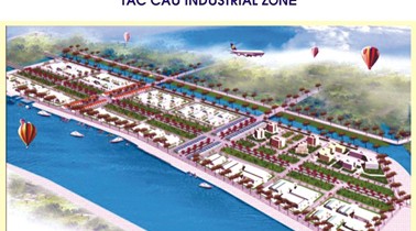
Major Industries
Rice, mining and aquaculture. |
|
| Annual Average Capital Of Enterprises | 61,937 billion dongs (2014) |
| Net Turnover | 72,314 billion dongs (2014) |
| Profit Before Taxes | 2,721 billion dongs (2014) |
| Profit Ratio | 3.73% (2014) |
| PCI | 60.31 (2015) - Rank: 11 |

Total Area: 100m2
Occupancy Rate: 100%
Address: Kien Luong, Kien Giang
Total Area: 64.5m2
Occupancy Rate: 100%
Address: Chau Thanh, Kien Giang
Total Area: 200m2
Occupancy Rate: 0%
Address: An Bien, Kien Giang, Vietnam

Total Area: 141m2
Occupancy Rate: 0%
Address: Thuan Yen, Ha Tien, Kien Giang
|
Transportation
Kien Giang has a network of road, water and air transport linking with other parts of the country and other nations in the region, creating good conditions for the home province in economic exchange and development. Thesedays, some road constructing projects are on the go and some others will soon be carried out such as the South Coastal Corridor Road, the Ho Chi Minh Road, the Phu Quoc Island’s Roads, the Lo Te – Rach Soi Expressway, and the Upgrading of Highway No.61,… Kien Giang’s two airports, Rach Gia and Phu Quoc, are in good condition with daily routes to and fro HCMC, meeting the travel demand of people and investors. |
|
|
Telecommunications
Kien Giang has a rather fast-developed post and telecommunications network along with the development of electricity and transport network. The network of post offices and agencies has reached the countrysides, remote areas and islands. All districts, wards, towns now have telephones. Such forms of services as mobil phone, broadband internet are provided in almost every district, ward and town within the province. |
|
|
Water Supply
There are 13 waterworks all over the province with designed capacity of 60,700m3/day, of which those in Rach Gia City make up for 34,000m3/day. In the short term, 87% of the fresh water demand for production and daily activities of the local people are met,… |
|
|
Electric Supply
All of Kien Giang’s districts and towns now have access to electricity. Electricity supply is mainly from National Grid; some plants have private power supply sources such as Sao Mai Cement Company and Ha Tien 2 Cement Company. In the future, a thermoelectric plant will be built at Kien Luong District to meet the domestic demand and export to neighboring countries. |
| People's Council | 647C Nguyen Trung Truc Street, An Hoa Ward, Rach Gia City, Kien Giang Province. |
| People's Committee | 06 Nguyen Cong Tru Street, Vinh Thanh Ward, Rach Gia City, Kien Giang Province. |
| Relevant Government Departments |
|
| Province | Kien Giang Province |
| Headquarter of People's Committee | 06 Nguyen Cong Tru Street, Vinh Thanh Ward, Rach Gia City, Kien Giang Province. |
| Official Provincial (or City) Website | www.kiengiang.gov.vn |


